
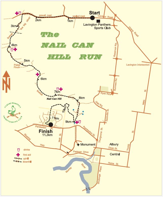
The course is run mainly along the ridge of the Nail Can Range that borders Albury on the west side.
The distance of the run is 11.3km. The route consists mainly of fire access tracks with short sections of gravel and bitumen roads. The course is marked with kilometre markers and directional arrows and lines. Walkers can expect to take up to 3 hours to complete the course.
Course Description
Section One
Start Line to 3.5 km
The Nail Can Hill run starts easily enough with the first 2km along flat roads, the first kilometre on sealed road and the second on gravel.
Soon after the two kilometre mark you will begin the long and in parts quite steep climb to the top of the range, for the less experienced runners and walkers it is advisable to begin the race conservatively so as to be still feeling fresh at the start of the climb.
At about 2.5km you will turn left through a gate and onto the Nail Can Range fire trail. There will be a drink station and first aid at this gate, you should take a drink here even if you don’t feel like it as you still have about 1km of climb left before you get some respite.
Your efforts will be rewarded during this section with some great views to the southeast (on your left). At about 3.5km you will pass through another gate with most of the climbing now behind you, time now to enjoy the bushland surrounding our city.
The elevation of the race start is 250 metres as you approach the high point you will have climbed to 405 metres
Section Two
3.5km to 7km
This is probably the most enjoyable section of the race with some easier ups and downs interspersed with some flat sections.
After passing through the top gate you have about 500metres of flat going to get your breath back followed by a short gentle rise to the high point of the course at about the 4km mark, where there will be another water and first aid station.
Soon after this you will encounter the first of the downhill sections, time now to stretch out those tight leg muscles. Just before the 5km mark there is another short sharp uphill known as Pete’s Pinch named after Peter Harper, one of the founders of the race.
From the top of Pete’s Pinch to the 7km mark is the easiest section of the course with a couple more downhills broken up by long flat sections.
A first aid station will be located at the 6km mark and water and first aid station at 7km. Remember the people manning these stations have given their time to help on the day so give them a smile and wave as you pass through.
Section Three
7km to 9km
Soon after the 7km mark you will again start to descend but don’t be fooled because there are still a couple more uphill sections ahead.
At the bottom of this descent you will come to a saddle with great views on your right over West Albury and the Murray River flood plain.
The height of the saddle is 295 metres meaning you have lost 110 metres of elevation since the high point at the 4km mark. Ahead of you the course continues sharply upward for about 100 metres, this is the last steep uphill for the day.
Just after the 8km mark you will reach the actual summit of Nail Can Hill, with the aptly named Hernia Hill track descending on your left, do not take this track, continue on straight ahead.
From here the track drops very steeply down towards Pemberton St. Approach this section with caution, it is wise not to run too fast down the steep hill if your legs are not used to it as you may find they will feel very heavy at the bottom and it will take some time to recover, also you would not want to undo all your hard work with a fall at this late stage of the race.
The elevation at Pemberton St is 215 metres meaning you have just dropped 100 metres in 1 kilometre since the top of Nail Can. At the 9 km mark, just before the Council water reservoir, you will take a sharp U turn to the right; you are now on the new part of the course.[/fruitful_tab]
Section Four
9km to the Finish 11.3km
Just after the 9km mark will be the final water and first aid station, make sure you take a drink here, you may think its not far to the finish and you don’t need it but by now the day will be starting to warm up and you still have a bit of work to do yet.
From 9km to just before the 10km mark the course is fairly flat as the track contours around the base of Nail Can Hill. Just before the 10km mark you will start to descend for about 200m down into a dry creek bed, there is a short sharp climb out of the creek then a more gentle climb for approximately another 200m.
From here the course is pretty much all gentle down hill so you should be able to stretch right out push hard for the finish.
At the top of the final climb you will come out into some open ground for about 200m, the track then dips down & up through a gully, swings around to the left then heads straight down through the bush corridor between the two West Albury housing estates. Cross Banksia St and continue towards the park, at the end of the houses there is a sharp right hand turn into the Bonnie Doon Park.
Proceed across the grass on the high side of the park to the football goal posts at the western end of the park; run around the goal posts and straight up the oval towards the eastern goal posts, the finish line will be about 20 metres short of the eastern goal posts.
Enjoy the run up the finishing chute and savour the moment as you cross the line knowing you gave it everything. There is always a great atmosphere amongst the crowd at the finish, enjoy swapping your experiences on the hill with your fellow competitors.
The elevation at the finish is 185 metres, compare this to the 250 metre elevation at the start and you will see that overall there is more downhill than uphill; those early hills don’t seem so hard after all.